Lands and Resources
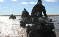 Fort Severn community members use information and communication technology for many lands and resources activities. Below is a short video describing these activities. Videos and photos can be important cues for people, as described in this quote from one Fort Severn interview participant:
| “See old people, when they see those, they like them ... they really like them. That's their traditional land. They seen this place before. They can name almost every picture where that is.” |
The video describes the utility and potential of ICT for lands and resources activities. However it it important to keep in mind some limitations, as described by a Fort Severn community member:
| “Traditional knowledge… means that you know almost every lake and river on the land….But if you know the lands, you grow up on the land the difference is that you are a survivor on the land. With the new technology like GPS, it can take you where you want to go. But one thing that doesn't tell you is the condition of the terrain. Like if you were to cross a creek like that during the night…and this little creek happens to be only about this thickness of ice — it's not frozen, eh — you'll be heading straight into the water. Even though that GPS tells you where your camp is, it doesn't tell you that ... That's the problem with the new technology.” |